SOUTH EAST ASIA
Our Anchorages
in South East Asia
Links inside this document: Indonesia, Singapore, Malaysia, Thailand. |
|
INDONESIA |
|
Our
anchorages in Indonesia (east to west):
Normally we do not provide way point lat/longs in this section,
but because there is little cruising info available to this area,
this is an exception - however, remember this is not a cruising guide
and there may be typing errors!
The route through Indonesia is covered in reports ## 53-57.
- Saumlaki, Yamdena island, Tanimbar Islands, the Capital of the region.
- Kolan Fanoter, Yamdena (S 7°49.12' - E 131°06.5')
Wide, but sheltered bay from all but W, no village.
- Welutu, Seira island (S 7°39.47' - E 131°02')
Five Christian villages ashore, very welcoming.
- Kilon, Yamdena (S 7°20.32' - E 131°26.05')
Islamic village, nice people.
- "NW bay", Wotap island (S 7°19.3' - E 131°14')
Deep anchorage (15-20m), fishermen working all around.
- Nila island, Banda Sea (S 6°43.1' - E 129°29.5') Anchor among coral
bommies in 10-20 m with violent wind gusts from the volcano.
- Teluk Wilhelmus, Damar island, (S 7°05.84' - E 128°39.6')
Very deep anchorage, anchor on shelf near shore in 15m.
Very nice Christian village, appeared relatively prosperous.
- Hila, Romang island (7 35.08' - E 127 21.9')
Sheltered from all but W. Christian friendly village ashore.
They tried to charge anchoring fee with bogus papers.
- "NE anchorage" Wettar island (S 7°37.94' - E 126°25.32')
An open roadstead, tolerable if there's no swell running.
- "Warm Springs", Wettar (S 7°51.1' - E 125°49.7')
Good shelter and nice surroundings. Poor but friendly village.
- Adenara island, NE anchorage (S 8°14.6' - E 123°19.6')
Very friendly, but again, poor people in Mako village.
- Lewoleba, Lembata island (S 8°22' - E 123°24')
First town after Saumlaki.
- Gedong, Flores island (S 8°04.63' - E 122°50.71')
Good shelter in SE trades, fishing camps ashore, deep.
- Sea World, Maumere, Flores (S 8°36.08' - E 122°50.71')
Anchor in front of resort with good restaurant, internet.
Can be choppy in afternoon sea breeze.
Boat vendors can arrange diesel delivered in jerry jugs.
- Naragunjong, Flores (8°30.55' - E 121°41.25')
A large bay where there may be a N'ly swell.
- Labuan Bajo, Flores (S8°31.12' - E 119°52.04')
This anchorage is in front of Eco Resort a mile south of town.
Stores and internet in town. Boat vendors.
- Loh Buaya, Rinca island (8°38.54' - E 119°42.92')
Komodo National Park ranger station. Take a walk and see
the famous Komodo dragons, the world's largest lizard.
- Gili Lawa Laut (8°26.84' - E 119°34.08')
Beautiful anchorage at uninhabited island.
Good diving and snorkeling.
- East Bay, Banta island (S 8°25.6' - E 119°19.5')
Good shelter, no village, strong currents in approach.
- Sangeang, Sumbawa island (S 8°17.6' - E 118°56.1')
Boat building village, charges a small anchoring fee.
Very persistent kids demand attention.
- Unamed bay, Sumbawa (S 8°15.9' - E 118°26.7')
Instead of going all the way to Kilo village, stage here
and save 5 nm on your way west the next day. No village,
therefore a welcome change from the constant attention.
- Kananga, Sumbawa (S 8°08.4' - E 117°46')
In front of village on NW coast, can be rolly.
Did not visit village.
- North West bay, Medang island (S 8°08.5' - E 117°22.4')
Beautiful spot at first low lying island we've visited in Indonesia
Good diving and snorkeling, no village on this side of island.
Other cruisers walked to village on SE side and had good
encounters with locals.
- Gili Lawang (S 8°17.7' - E 116°41.4')
Easy enough to enter in good light and calm seas, but tricky
to depart at dawn, especially if there's ripples on the surface.
- Gili Air (S 8°21.9' - E 116°04.9')
Nice sandy tourist island, but choppy in the anchorage
during afternoon southerlies. Moorings provided, but
quality unknown. We shifted to:
- Kombal bay, Lombok island (S 8°24.3' - E 116°04.6')
Just 2.5 nm south of Gili Air. Well sheltered.
Picked up a mooring, which "looked good", for 3 USD
per night. Tours of Lombok can be arranged.
Boat vendors can arrange water, diesel (in jugs) etc.
- Lovina Beach, Bali island (S 8°09.6' - E 115°01.3')
On the north coast of Bali. Very convenient if you want to avoid
the trip south through Lombok strait with its currents to Bali marina
(and back north again on departure for Singapore etc)
.
Easy to get land transportation all over Bali while the yacht is
anchored at Lovina. Although technically "exposed", this anchorage
is probably very safe during the dry season.
- Kumai town, Kalimantan, Borneo (S 2°44.3' - E 111°44.1')
Central Kalimantan, Borneo island.
30 miles from the Java Sea up the Kumai river is the gateway for the
Tanjung Puting national park, home of the enigmatic orang-utans.
- Gelam island, Java Sea (S 2°52.5' - E 110°08.8')
120 miles from Kumai we stopped over night. Anchored in 5m.
Protected from SE. Houses ashore, saw no people though.
- Mesenak island, South China Sea (N 0°25.7' - E 104°31.6')
Anchored in N bay, good protection, but swell during our visit.
Some houses ashore. Fishermen work the area.
- Nongsa Point Marina, Batam island, Singapore Strait
A five star resort, but very reasonable prices. Probably the
finest and friendliest marina we have visited.
|

Indonesia

Click
on map
for a blow up
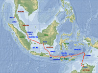
Our track
Click
on map
for a bloww up
|
| SINGAPORE |
|
We only made one stop in Singapore, see report #57:
- Raffles Marina
An other luxury marina, but not as shining-new as Nongsa Point.
A one-hours trip downtown, but the connections are excellent.
Singapore is a "one city state" and a real success story.
For a brief period, after getting independent from British rule,
the country was part of Malaysia. In 1964 they declared
independence and in a surprisingly short time succeeded
in lifting the country out of poverty - unlike its neighbours,
Malaysia and especially Indonesia. |

Singapore
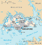
Click for larger map
|
| MALAYSIA |
|
Scorpio's anchorages in Malaysia (south to north):
A. Here's a list of our stops on the route from Singapore to Langkawi
(in October 2009, which is the transition period between the monsoons),
covered in report #58:
Keep in mind that the lat/longs given are approximate!
- Pisang island, 32nm from Raffles Marina.
(N 1°28' - E 103°16.3')
Not a perfect anchorage, but comfortable and safe enough, in settled
weather, for an over night stop on the way north or south.
Good holding in 4-5m.
- Besar island, Water Islands, 69nm from Pulau Pisang.
(N 2°06.55' - E 102°20.50')
Same type of anchorage as Pisang.
Good holding in 4-5m.
- Admiral Marina, Port Dickson, 42nm from Pulau Besar.
Use approach wps given in Southeast Asia Cruising Guide.
Friendly first class marina. A one hour ride to the old colonial
city of Malacca or a long day's trip to Kuala Lumpur.
Wifi on the terrace.
- Port Klang, at a floating jetty off the Royal Selangor Yacht Club.
60nm from Admiral Marina.The jetty is very run down,
but the club is friendly. They have a ferry service that picks
you up from the jetty, which is not connected to shore.
One hour by train to Kuala Lumpur. Wifi at the Clubhouse.
- Angsa island, 12nm from Royal Selangor Yacht Club.
We anchored close east of the gap between the islands.
in 10m. Caution, it gets shallow fast after 15m.
You can also anchor to the south of the islands in shallower
water, but that spot is more exposed.
- Nipah bay, Pangkor island, 60nm from Angsa.
(N 4°14' - E 100°32.6')
Can be rolly, but probably the best anchorage between Port Klang
and Georgetown if you prefer not to go in to Lumut.
- Talang island, 12nm from Nipah. East of the island, between the
island
and the mainland. Can be rolly, but shortens the distance
to Georgetown next day. Enter from either end.
- Tanjong City Marina, Georgetown, Penang island 62nm from Talang.
A lot of surge inside the marina from ferry traffic and tidal currents,
but not as bad as expected. Friendly place and a great city!
Wifi at a restaurant on the dock near the office, or buy a prepaid
broadband card.
B. Langkawi anchorages (all well documented in cruising guides,
therefore I wont give any descriptions, except Monkey Creek):
Our first survey of the area is covered in report #59.
- Monkey Creek, Gubang Darat island, Langkawi,
60nm from Georgetown.
(N 6°12' - E 99°46.75' is in the south part, we anchored further N)
A very picturesque anchorage in a channel with deep water
throughout between the island of Gubang Darat and the cliffs of
Dayang Bunting island, in an area aptly called "The Fjords".
Enter from either end and anchor in 7-11 metres. Sheltered in
both season’s this is a great spot with excellent holding ground.
A good spot to celebrate that you have finally reached Langkawi.
- Dayan Bunting bay (Pantai Dayan Bunting)
- Langkawi Royal Yacht Club, Kuah
- Kuah anchorage, Bass harbour
- Jerong Belanga point (Tanjung Jerong Belanga), Bass harbour
- Tengah bay (Pantai Tengah)
- Rebak beach
- Rebak Marina
- Sanctuary bay (Pantai Sanctuary)
- Datai bay (Pantai Datai)
- Rhu point (Tanjung Rhu)
- Hole in the Wall
- Timun island (Pulau Timun)
- Telaga Marina, where we used to stop only to top up
the fuel and water tanks before sailing to Thailand.
|

Malaysia
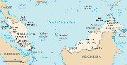
Click for larger map

Our track Singapore to Langkawi
Click
on map
for a blow

Our cruise around Langkawi island
Click
on map
for a blow
|
| THAILAND |
|
Scorpio's anchorages in Thailand:
Again, these anchorages are all found in cruising guides,
so I wont give any way points.
- Koh Lipe (NE side), Butang islands
- Ko Adang (west coast), Butang islands
- Ban Ao Makham, Ko Tarutao
- Koh Phetra west
- Koh Rok Nok
- Had Khlong Dao, Koh Lanta
- Yongkasem bay, Phi Phi Don island
- Ton Sai Bay, Phi Phi Don
- Ao Chalong, Phuket
- Panwa Beach, Phuket
- Au Yong, Phuket
- Nai Harn Bay, Phuket

Our first route, Langkawi - Phuket.
Click for larger map. which includes the return route
- Kata Bay, Phuket
- Koh Racha Yai
- Koh Rang Yai
- Boat Lagoon Marina, Phuket
- Ao Po, Phuket
- Koh Naka Noi
- Ao Labu north, Kaoh Yao Yai
- Koh Wa Yai (west)
- Leam Phrao (in front of Yacht Haven Marina)
- Koh Phanak southwest, Phang Nga Bay
- Koh Hong, Phang Nga Bay
- Koh Yang (near James Bond Island), Phang Nga Bay
- Koh Roi, Phang Nga Bay
- Ao Nang, Krabi
- Rai Lei Bay, Laem Nang
- Koh Dam Khwan, Krabi
|
Thailand
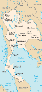
Click for larger map
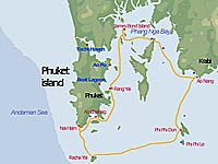
Suggested 2 week cruise
east of
Phuket.Click for larger map.
Read more ..
|